Sao Tome and Principe – Facts Geography History Travel
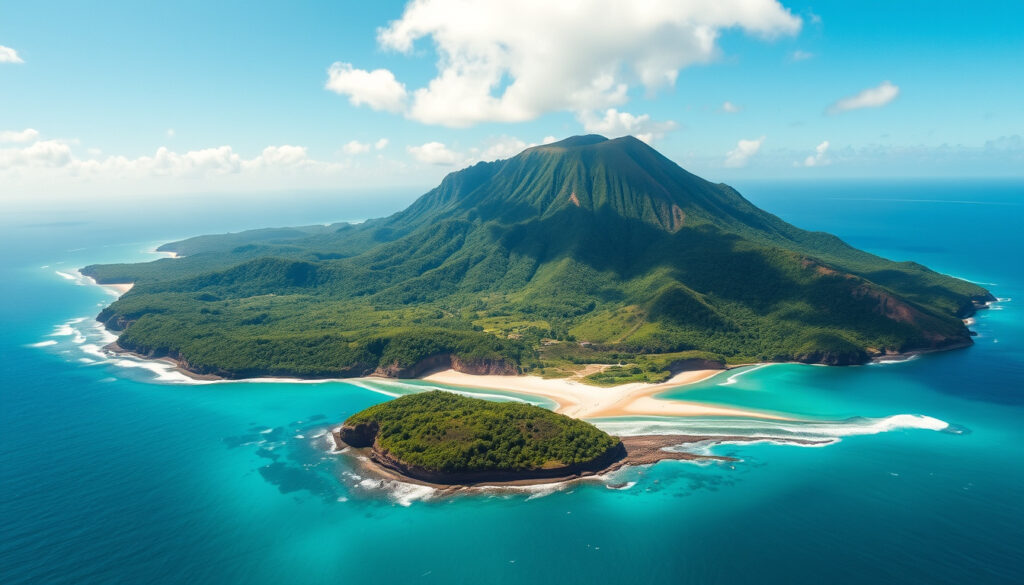
São Tomé and Príncipe is a volcanic island nation nestled in the Gulf of Guinea, approximately 250 kilometers off the equatorial west coast of Central Africa. Comprising two primary islands—São Tomé and Príncipe—along with several smaller islets, the country spans a mere 964 square kilometers, making it Africa’s second-smallest nation by area and population after Seychelles. Despite its modest size, this Portuguese-speaking archipelago carries a rich historical legacy shaped by colonialism, the transatlantic slave trade, and a transition to independence in the 20th century.
The islands emerged from extinct volcanoes, their terrain marked by dramatic peaks including São Tomé Peak at 2,024 meters and Príncipe Peak at 948 meters. This mountainous landscape, combined with the islands’ equatorial location and isolation from the mainland, has fostered extraordinary biodiversity. Today, São Tomé and Príncipe operates as a democratic republic, with Portuguese serving as the official language alongside several creole and regional dialects. The nation has positioned itself as an emerging tourism destination, celebrated for its pristine beaches, endemic wildlife, and the sobriquet “African Galápagos” earned through its unique ecological heritage.
Understanding this island nation requires examining its geography, governance structures, demographic composition, economic foundations, and historical trajectory. Each facet contributes to a comprehensive picture of a small but culturally significant country working to develop its potential while preserving its distinctive character.
Where is São Tomé and Príncipe Located?
Geographic positioning places São Tomé and Príncipe at the intersection of Central and West Africa, within the Gulf of Guinea. The two main islands sit approximately 150 kilometers apart, with São Tomé located roughly 250 kilometers northwest of Gabon and Príncipe positioned 224 kilometers northwest of the Gabonese coast. The nation lies entirely within the Western Hemisphere, operating on UTC+0 (GMT) time zone.
São Tomé, the larger island, encompasses 854 square kilometers, while Príncipe covers 136 square kilometers. The islands’ proximity to the African mainland—225 kilometers at their nearest point—has facilitated cultural and economic connections throughout history, though their island status has also encouraged distinctive development patterns. Seven administrative divisions structure the country: six districts on São Tomé and one autonomous region known as Pagué on Príncipe, established in 1995.
Gulf of Guinea, Central Africa
São Tomé City
~223,000 (2024 est.)
Portuguese (official)
- Africa’s second-smallest country by both area and population after Seychelles
- Volcanic origin with extinct volcanoes and dramatic peaks including 2,024m São Tomé Peak
- Equatorial climate with year-round warmth and distinct wet and dry seasons
- Island isolation has created unique endemic biodiversity earning the “African Galápagos” nickname
- Strategic position in the Gulf of Guinea along major maritime shipping routes
- GMT time zone (UTC+0) matching the UK and Portugal
- Two-island configuration with Príncipe lying closer to mainland Africa at 225 km offshore
| Category | Details |
|---|---|
| Total Area | 964 sq km |
| São Tomé Island | 854 sq km |
| Príncipe Island | 136 sq km |
| Highest Point | São Tomé Peak (2,024 m) |
| Time Zone | UTC+0 (GMT) |
| Administrative Divisions | 7 districts (6 on São Tomé, 1 autonomous on Príncipe) |
| Distance from Gabon | 250 km (São Tomé), 224 km (Príncipe) |
| Notable Volcanic Feature | Cão Grande pinnacle (663 m) |
Is São Tomé and Príncipe a Country?
São Tomé and Príncipe indeed functions as an independent sovereign nation, formally known as the Democratic Republic of São Tomé and Príncipe. The country gained independence from Portugal on July 12, 1975, following Portugal’s military coup in 1974. Since independence, the nation has maintained democratic governance structures, operating as a republic with an elected president serving as head of state.
The country maintains membership in the United Nations, the African Union, and the Community of Portuguese Language Countries (CPLP). Its small island status presents both challenges—limited natural resources, vulnerability to climate change, and geographic isolation—and advantages, including exclusive maritime zones and a distinctive national identity rooted in centuries of cultural blending.
Government and Capital of São Tomé and Príncipe
The capital city of São Tomé, founded in 1493 as the first Portuguese settlement on the island, serves as the nation’s political, economic, and cultural center. With approximately 229,600 inhabitants, the capital houses the majority of the country’s population and hosts most governmental institutions. The city’s founding predates the establishment of many other African capitals, reflecting Portugal’s early interest in establishing trading posts along the West African coast.
As a democratic republic, São Tomé and Príncipe operates under a presidential system where the president serves as head of state, supported by a prime minister who leads the government. The country’s political landscape opened to multi-party democracy in 1990, transitioning from single-party rule established after independence. General elections determine both presidential and parliamentary representation, with the president serving a maximum of two five-year terms.
The National Flag
The national flag of São Tomé and Príncipe features horizontal stripes in green, yellow, red, black, and white, with a configuration that carries symbolic meaning. Two black stars on a yellow triangle occupy the hoist side, representing the two main islands. The color scheme reflects connections to Africa (black), the tropical environment (green), and the sun (yellow), while red acknowledges the struggle for independence. A yellow star appears above the black stars, symbolizing the nation itself.
Leadership Structure
The presidency represents the executive authority within the democratic framework, with the current leadership operating alongside an elected National Assembly. The president appoints the prime minister, who in turn forms the cabinet. Political stability has characterized the post-transition period, though competitive elections ensure accountability and diverse representation in governance.
Governance Context
The 1990 transition to multi-party democracy marked a significant turning point in the nation’s political development, establishing institutions that continue to function within the democratic republic framework established after independence in 1975.
People, Language, and Currency in São Tomé and Príncipe
Population estimates place the nation at approximately 223,561 residents as of 2024, representing steady growth from earlier counts of 201,800 in 2018 and 196,548 recorded in the 2007 census. The population concentrates heavily on São Tomé Island, where approximately 193,380 people reside, while Príncipe accommodates around 8,420 inhabitants. Annual population growth approaches 4,000 individuals, driven by natural increase rather than significant immigration.
The demographic composition reflects the islands’ complex colonial history. Most inhabitants trace ancestry to Portuguese-imported settlers, enslaved Africans brought to work plantations, convicts exiled by colonial authorities, and Jewish deportees who arrived during various periods of persecution in Europe. This diverse genetic and cultural heritage manifests in the nation’s distinctive social fabric, music traditions, and culinary practices.
Official and Regional Languages
Portuguese serves as the official language of São Tomé and Príncipe, a legacy of colonial rule that continues to shape education, government, and formal communication. However, the linguistic landscape extends well beyond Portuguese. Forro functions as the primary native creole, spoken by the majority of the population as an everyday language. Additional creoles include Cabo Verdian and Angolar, each reflecting historical migration patterns and cultural exchanges.
French maintains importance given the nation’s geographic proximity to French-speaking African nations, while English has gained prominence through tourism development and international business engagement. This multilingual environment reflects both the islands’ colonial past and their contemporary positioning within regional and global networks.
National Currency
The Dobra (STN) serves as São Tomé and Príncipe’s national currency. Introduced following independence, the Dobra has undergone changes reflecting economic conditions and monetary policy adjustments. The currency code STN identifies the Dobra in international financial transactions.
Demographic Highlights
Life expectancy reaches approximately 70 years, infant mortality remains relatively low, and universal access to water and electricity characterizes living conditions. Education enrollment is comprehensive, with all children participating in schooling—a testament to post-independence investment in human development.
History of São Tomé and Príncipe
The islands remained uninhabited until Portuguese explorers João de Santarém and Pedro Escobar arrived on December 21, 1470. The Portuguese immediately recognized the strategic potential of the volcanic islands, with their rich soils and strategic position along West African coastal routes. Colonization accelerated during the 16th century as Portugal established sugar plantations, creating massive demand for labor that would reshape the region’s demographic and social landscape.
Enslaved Africans from Angola, Kongo, and other mainland regions arrived in substantial numbers, fundamentally altering the islands’ population composition. The trade networks established from São Tomé and Príncipe reached remarkable scale; historical records indicate that approximately 75 percent of enslaved people entering Brazil before 1580 passed through São Tomé. Many enslaved individuals escaped to the interior, establishing communities known as macambos that preserved African traditions and languages.
The Cocoa Era and Economic Transformation
The shift from sugar to cocoa production occurred during the 19th century, eventually positioning São Tomé and Príncipe as the world’s leading cocoa producer by 1905. The islands earned the moniker “Chocolate Islands” during this period, with cocoa exports reaching 54 to 95 percent of total export value. Coffee cultivation also expanded during this transition, diversifying agricultural output.
Plantation agriculture, known locally as roças, characterized the cocoa economy. These large estate operations maintained strict hierarchical structures, and historical accounts document abusive labor practices that persisted well after formal slavery abolition in 1876. Forced labor arrangements continued into the early 1900s, creating lasting social stratification that influenced post-independence land reform policies.
Independence and Modern Era
Following Portugal’s military coup in April 1974, São Tomé and Príncipe entered negotiations that led to independence on July 12, 1975. The new government immediately implemented sweeping agricultural reforms, with the state assuming control of approximately 90 percent of plantation lands. This transformation restructured the economy, shifting from export-oriented plantation agriculture to more distributed smallholder production while maintaining cocoa’s central economic role.
Travel and Economy in São Tomé and Príncipe
Tourism in São Tomé and Príncipe remains limited compared to other African destinations, with annual visitor numbers ranging between 20,000 and 39,000 before the COVID-19 pandemic. The 2017 figure of approximately 29,000 tourists positioned the nation as Africa’s second-least visited destination after Equatorial Guinea. This exclusivity appeals to travelers seeking uncrowded destinations, pristine natural environments, and authentic cultural experiences.
The islands have garnered international recognition through inclusion in travel publications. Lonely Planet named São Tomé and Príncipe to its top 10 destinations list in 2019, citing the archipelago’s “African Galápagos” status, world-class beaches, and emerging ecotourism opportunities. The Cão Grande volcanic plug, standing at 663 meters, ranks among the most dramatic geological landmarks, while numerous endemic species attract nature enthusiasts seeking biodiversity experiences unavailable elsewhere.
Economic Foundations
Agriculture continues to anchor the economy, with cocoa remaining the primary export commodity. Coffee, copra, and palm kernels contribute additional agricultural output. Major export destinations include the United Kingdom, Netherlands, and Belgium. Despite historical dominance of cocoa in export earnings, the sector has faced challenges including aging trees, disease pressure, and volatile global prices.
Economic indicators reveal modest but meaningful development. The nation outperforms many sub-Saharan African countries on Human Development Index measures, reflecting investments in education, healthcare, and infrastructure since independence. GDP estimates place the economy at approximately $500 million, while economic growth has registered around 4.1 percent in available data periods.
Infrastructure Considerations
Limited tourism infrastructure characterizes the destination, with accommodations, transportation, and services less developed than in mainstream tourist markets. Visitors should anticipate fewer western-style amenities and plan accordingly for a more adventurous travel experience.
Safety and Practical Considerations
The nation’s low tourism volume partly reflects limited tourism infrastructure rather than documented safety concerns. General precautions advisable in any developing destination apply, including standard health precautions and awareness of local conditions. The equatorial climate ensures year-round warmth, with a typically drier period from June through September marking the most comfortable time for outdoor exploration.
Visa requirements vary by nationality, and prospective visitors should consult official sources before travel planning. The nation’s growing tourism sector has prompted infrastructure improvements, including airport enhancements and accommodation development, suggesting increasing accessibility for future travelers.
Timeline of Key Events in São Tomé and Príncipe
The historical trajectory of São Tomé and Príncipe spans from uninhabited volcanic islands to independent democratic nation. This timeline presents major inflection points in the archipelago’s development.
- December 21, 1470: Portuguese explorers João de Santarém and Pedro Escobar discover the uninhabited islands.
- 16th century: Portuguese colonization accelerates; sugar plantations established using enslaved African labor.
- Pre-1580: São Tomé becomes a key node in the transatlantic slave trade, supplying approximately 75 percent of enslaved people entering Brazil.
- 1876: Slavery formally abolished throughout Portuguese colonies, though forced labor arrangements persist.
- 19th century: Transition from sugar to cocoa and coffee cultivation; emergence of the “Chocolate Islands” era.
- 1905: São Tomé and Príncipe becomes the world’s leading cocoa producer.
- July 12, 1975: Independence achieved following Portugal’s 1974 military coup.
- Post-1975: State takes control of 90 percent of plantation lands, restructuring agricultural economy.
- 1990: Transition to multi-party democracy; political reforms open governance to competitive elections.
- 1995: Príncipe gains autonomous region status under the name Pagué.
What We Know and What Remains Uncertain
Clear documentation supports numerous aspects of São Tomé and Príncipe’s geography, governance, and history, while other areas remain less comprehensively documented or have changed in ways that limit current accuracy.
| Established Information | Uncertain or Estimated Information |
|---|---|
| Total area: 964 sq km | Current GDP figures vary across sources |
| Capital founded 1493 by Portuguese | Precise current exchange rates for Dobra |
| Independence date: July 12, 1975 | 2024 visitor numbers post-pandemic recovery |
| Official language: Portuguese | Specific current president name not confirmed across all sources |
| Highest point: São Tomé Peak (2,024 m) | Detailed visa policy specifics by nationality |
| Slavery abolished 1876 | Tourism safety data requires independent verification |
Context: São Tomé and Príncipe in the Modern World
Within the African continental context, São Tomé and Príncipe occupies a distinctive position. Its island geography, Portuguese colonial heritage, and creole linguistic landscape differentiate it from mainland African nations. The country’s small population and limited economic scale belies its disproportionate historical significance in global trade networks and its contemporary potential in specialized tourism and conservation sectors.
The nation’s approach to economic development reflects careful balancing between agricultural traditions and emerging opportunities. Cocoa production, while diminished from its early 20th-century peak, remains economically significant. Tourism development emphasizes the islands’ unique biodiversity assets, positioning the archipelago as a destination for ecotourism rather than mass-market travel. This strategy protects environmental assets while generating economic returns.
Geopolitically, São Tomé and Príncipe maintains relationships with former colonial power Portugal while engaging actively with African regional organizations and international development partners. The country’s exclusive maritime economic zones represent potential resources as global interest in sustainable fisheries and seabed minerals grows. Climate change vulnerability, shared by small island nations worldwide, presents ongoing challenges requiring adaptation and international cooperation.
Sources and References
This overview draws upon established reference sources documenting São Tomé and Príncipe’s geography, history, and contemporary characteristics.
“Two islands in the Gulf of Guinea, off the western equatorial coast of Central Africa, close to the continent’s second-largest river, the Congo River.”
— Britannica, São Tomé and Príncipe: Country Profile
“The islands lie about 150 km apart, 250 km and 224 km northwest of Gabon. They are volcanic and mountainous, the largest island rising to 2,024 metres at São Tomé Peak.”
— Wikipedia, São Tomé and Príncipe
- Britannica Editorial Team. “São-Tome-and-Principe.” Encyclopædia Britannica. Updated 2023.
- Wikipedia Contributors. “São Tomé and Príncipe.” Wikipedia, The Free Encyclopedia. Accessed 2024.
- Facts Institute. “Facts About São Tomé and Príncipe.” Facts Institute Country Profiles. Updated 2024.
- CIA World Factbook. “São Tomé and Príncipe.” Central Intelligence Agency. Updated 2024.
- United Nations Statistics Division. “Country Profile: São Tomé and Príncipe.” UN Data. Accessed 2024.
Key Takeaways
São Tomé and Príncipe represents a small but historically significant African nation characterized by volcanic island geography, Portuguese colonial heritage, and a distinctive multicultural society. The country’s population of approximately 223,000 concentrates on two main islands, with Portuguese serving as the official language alongside several creole dialects. Economic activity centers on cocoa cultivation and emerging tourism, with the islands attracting recognition as an “African Galápagos” destination for biodiversity and ecotourism. The nation’s independence from Portugal in 1975 initiated political and economic transformations that continue to shape contemporary development trajectories.
For those exploring other island destinations or understanding regional cultural calendars, São Tomé and Príncipe offers a compelling case study in how small island nations navigate development challenges while preserving unique cultural and natural heritage.
Frequently Asked Questions
Is São Tomé and Príncipe safe for tourists?
The nation has no major security advisories, though limited tourism infrastructure means travelers should exercise standard precautions and plan for an adventure-oriented experience with fewer western amenities than mainstream destinations.
What currency is used in São Tomé and Príncipe?
The Dobra (STN) serves as the national currency. Currency exchange facilities exist in the capital and at banking institutions, though advance preparation is advisable for travel outside main urban areas.
What is the best time to visit São Tomé and Príncipe?
The drier season from June through September generally offers the most comfortable conditions for outdoor activities, though the equatorial climate ensures warmth year-round.
Is a visa required to visit São Tomé and Príncipe?
Visa requirements vary by nationality. Visitors should consult official government resources or their nearest diplomatic mission for entry requirements specific to their citizenship before planning travel.
What is São Tomé and Príncipe known for?
The archipelago is celebrated for its cocoa production history, extraordinary biodiversity earning the “African Galápagos” nickname, pristine beaches, volcanic landscapes including the Cão Grande pinnacle, and unique blend of Portuguese and African cultural influences.
What language is spoken in São Tomé and Príncipe?
Portuguese serves as the official language. Native creoles including Forro, Cabo Verdian, and Angolar are widely spoken, while French and English serve as additional languages for business and tourism purposes.
How large is the economy of São Tomé and Príncipe?
The economy relies primarily on cocoa agriculture, which historically represented 54 to 95 percent of export earnings. GDP estimates place the economy at roughly $500 million, with cocoa, coffee, copra, and tourism as key economic sectors.
How many tourists visit São Tomé and Príncipe annually?
Annual tourism has ranged between 20,000 and 39,000 visitors in recent pre-pandemic years, positioning the nation among Africa’s least-visited destinations—an exclusivity that appeals to travelers seeking uncrowded experiences.
More related posts
 Disney Cruise Auckland 2025: Schedule, Prices & Tickets
 Home Insurance Quote Online Ireland: Compare & Save Up to 35%
 Foxglove Bar & Kitchen: Wellington Waterfront Guide
 Best Stroller Travel Systems: Top Tested Picks 2024
 Xbox Game Pass Ultimate: $29.99 Price Hike & Deals
 Cast of Blade Runner 2049: Full Actors & Roles List
 Loan for Home Calculator – EMI Formula and Examples
 Mitre 10 Trade Hub: Login, Benefits & SmartMate Guide